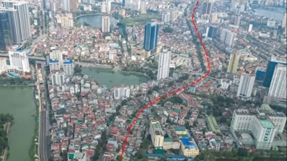
We will start from the center and move outward, beginning with Belt Road 1. This route is considered the heart of Hanoi's traffic. It is the smallest circular road that encircles the central area of Hanoi, where Hoan Kiem Lake, the Old Quarter, and streets rich in historical significance are located. With a length of about 10 kilometers, this small road is extremely important, connecting the central districts and is where the liveliest pace of life in Hanoi takes place.
Belt Road 1
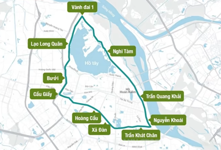
The route of Belt Road 1 includes streets such as Tran Khat Chan, Dai Co Viet, Xa Dan, O Cho Dua, De La Thanh, Hoang Cau, Cau Giay, Buoi, Lac Long Quan. Au Co, Nghi Tam, Yen Phu, Tran Nhat Duat, Tran Quang Khai, Tran Khanh Du, Nguyen Khoai are all located on Belt Road 1. The scope of this route runs through areas such as Cau Giay, Tay Ho, Ba Dinh, Hoan Kiem, Hai Ba Trung, and old Dong Da. It must be said that now, if we do not name the old districts, it is very difficult to distinguish. Belt Road 1 is also the main urban axis connecting from east to west through the central area of Hanoi.
Geographically, Belt Road 1 is understood as the urban area surrounding the historical center of Hanoi, near the Red River, where the terrain is flat and densely populated. This road passes through iconic areas such as the Old Quarter near Hoan Kiem Lake or the Ba Dinh area. Being in the center, Belt Road 1 faces high population density, markets, and a series of high-rise buildings that have sprung up in recent years. This makes traffic on this road always tense.
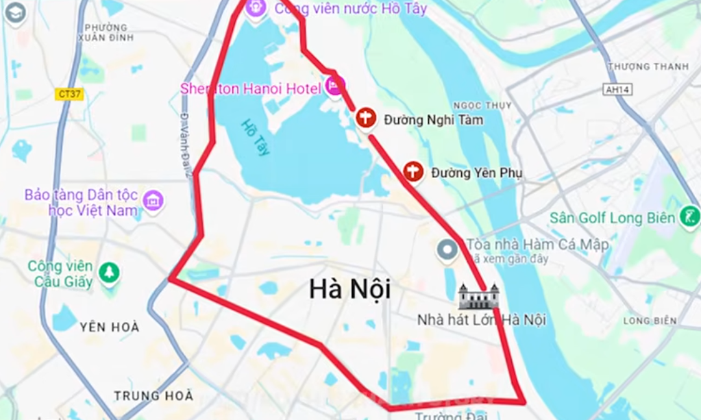
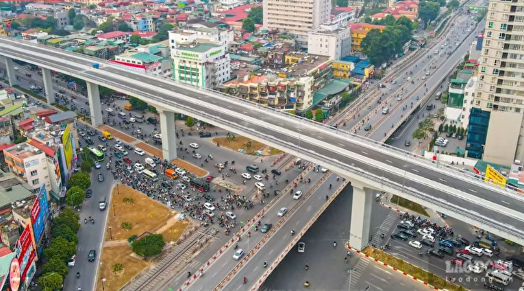
Here, you can fully experience the flavor of Hanoi's traffic, especially traffic jams. The stream of motorbikes and cars jostles, the honking is deafening, the smoke from vehicles is thick, and street vendors weave through the traffic. All of this creates a colorful traffic picture, and of course, it is also full of challenges. To reduce congestion, Hanoi is building overpasses and underpasses, and many have already been constructed. These projects help vehicles move better but do not always completely solve the problem.
One issue is the Hoang Cau - Voi Phuc route. This route is expected to be over two kilometers long but is still not completed due to difficulties in land clearance. Notably, from July 2026, Hanoi plans to ban gasoline-powered motorbikes in the Belt Road 1 area. This regulation aims to reduce air pollution and encourage the use of public transport or electric vehicles. It can be said that Belt Road 1 is not just a road but also a historical witness of Hanoi passing through old blocks like Yen Phu, Dong Ngac, Kim Lien, Cho Dua, Cau Giay, Buoi, names that evoke memories of old Hanoi.
Belt Road 2 - The bridge between the inner city and the suburbs
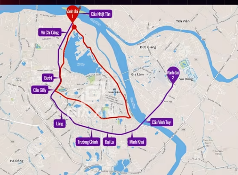
Next, let's drive out to Belt Road 2, a larger road that surrounds the expanded urban area. If Belt Road 1 is the heart, then Belt Road 2 is a wide embrace that encompasses both the center and new urban areas. With a length of over 40 kilometers, Belt Road 2 plays a role in connecting the inner city with surrounding areas, reducing pressure on Belt Road 1 and promoting the development of modern urban areas.
Let's start from Vinh Tuy Bridge, the bridge crossing the Red River, connecting Long Bien with the city center. From here, Belt Road 2 runs through areas like Minh Khai, which has bustling urban areas, notably Time City. Next are places like Dai La, Nga Tu Vong. This is a busy intersection with shopping centers and eateries. Then it goes through Truong Chinh, the famous road, and reaches Nga Tu So.
From Nga Tu So, Belt Road 2 continues through Lang, the old tree-lined road that is always crowded, leading you to areas like Buoi Street connecting with Vo Chi Cong near West Lake via Nhat Tan Bridge, then looping around the roads on the other side. Finally, the route returns to Nguyen Van Linh, Dam Quang Trung back to Vinh Tuy Bridge, completing a loop. The old districts that Belt Road 2 passes through include Long Bien, Hai Ba Trung, Hoang Mai, Thanh Xuan, Dong Da, Ba Dinh, Cau Giay, Tay Ho, and Dong Anh.
Geographically, Belt Road 2 passes through both flat areas near the Red River and other elevated areas. This road not only connects the inner city but also reaches suburban areas, where Hanoi is expanding rapidly. This makes Belt Road 2 a bridge between traditional Hanoi and modern Hanoi. Traffic on Belt Road 2 is planned to be more modern than Belt Road 1 thanks to elevated sections like Nga Tu So and Nga Tu Vong that have been opened for a long time and previously closed routes. However, many sections are severely congested.
For example, the section from Nga Tu So down to Truong Chinh. Because the number of vehicles here is two to three times higher than designed, making Nga Tu So a bottleneck, and we have been calling it a bottleneck for many years. Now, Belt Road 2 is still one of the most important and challenging routes. The city has implemented traffic light adjustments based on real-time data and installed additional surveillance cameras according to recent updates. In addition, some lower roads are also being upgraded to improve the road surface. Belt Road 2 is not just a traffic route but also a driving force for real estate development. Urban areas along Belt Road 2 are sprouting up along this route, making it a symbol of modernization.
Belt Road 3 - The road of suffering.
This road is likened to the lifeblood of traffic connecting Hanoi with neighboring provinces, with a length of about over 60 kilometers. It is the largest road among the three belt roads. In short, the three inner belt roads, not the outer belt roads, play the role of trade gateways for the capital. If you want to travel from Hanoi to other provinces, for example, Hai Phong, Thai Nguyen, Lao Cai, you will definitely have to go through Belt Road 3.
Let's start from Vo Van Kiet, the modern road in northern Hanoi. From here, Belt Road 3 goes through Pham Van Dong, a wide road both above and below. Then to Pham Hung, Khuat Duy Tien, where the National Convention Center is located. Next is Nguyen Xiển, Nguyen San Yen, Phap Van Overpass connecting with Thanh Tri Bridge. From here, it runs through the new National Highway 1A and then back to Ninh Hiep to the starting point.
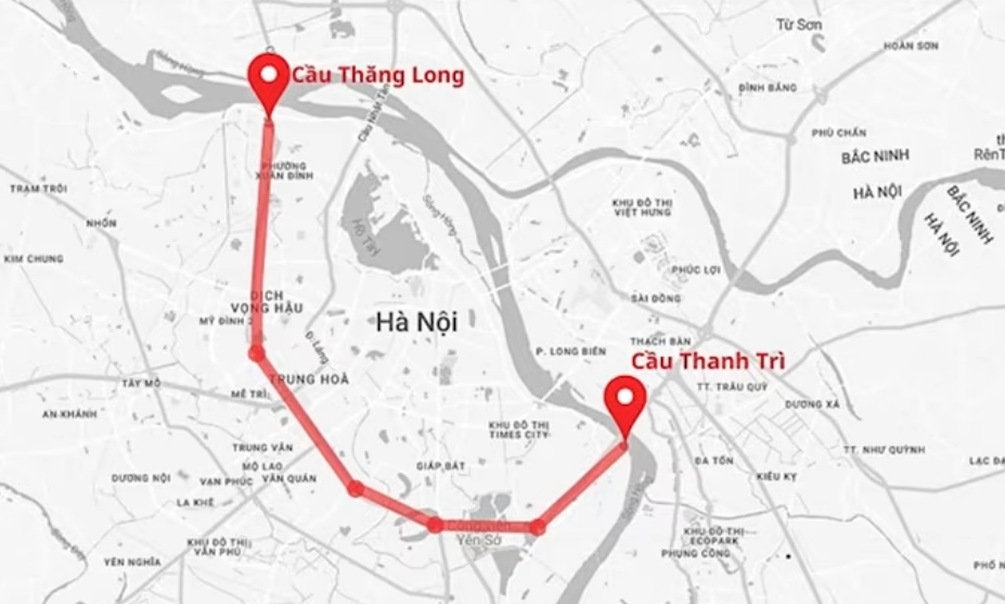
The old districts and towns that Belt Road 3 passes through include Dong Anh, Nam Bac Tu Liem, Cau Giay, Thanh Xuan, Thanh Tri, Hoang Mai, Long Bien, and Gia Lam. This road also connects with important highways such as Hanoi-Hai Phong, Hanoi-Thai Nguyen, Hanoi-Lao Cai, making it an indispensable inter-regional traffic axis. Notable bridges include Thang Long Bridge, Thanh Tri Bridge, and Phu Dong Bridge, all iconic constructions of Hanoi.
Geographically, Belt Road 3 passes through both the lowland area near the Red River and higher areas in the west and south like Loc Khuat Duy Tien or Pham Hung. This road also connects developed areas like My Dinh or Ha Dong with industrial zones in Dong Anh and Gia Lam. This makes Belt Road 3 a bridge connecting Hanoi and neighboring provinces, supporting both traffic and trade. It is also the first road in Hanoi with elevated sections according to highway standards. Although it is called highway standard, few can travel at highway speeds because Belt Road 3 is currently overloaded with vehicle traffic many times higher than its designed capacity. This is still the hottest road in terms of traffic in Hanoi. During peak hours, you can only get on Belt Road 3.
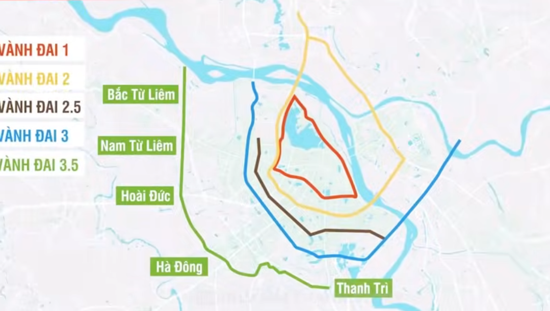
Intersections like Thanh Xuan, Khuat Duy Tien, and Tran Duy Hung often fall into a situation of crawling meter by meter, especially during peak hours. And especially the section of Thanh Tri Bridge is beyond words. To address this, Hanoi has adjusted traffic light timings and implemented an intelligent traffic system based on real-time data. But in short, with so many vehicles, how can adjustments be made? Through Belt Road 3, an important piece of information is that Hanoi is accelerating the planning and development of new belt roads, Belt Road 3.5 and Belt Road 4 to reduce the load on Belt Road 3. The land prices in these areas are skyrocketing.
In the meantime, Belt Road 3 remains the most pressured road. It is not just an ordinary traffic route but also a driving force for regional economic development. It supports the transportation of goods from industrial zones in Soc Son, Quang Minh, Bac Thang Long, promoting the development of new urban areas in Hoai Duc, Thanh Tri, Dong Anh, and even further to neighboring provinces. That is the detailed picture of the three belt roads.
The overall picture of the three belt roads
What is Belt Road 1? It is the heart embracing the historical center but often congested due to high population density. Belt Road 2 is a wider embrace, connecting the inner city with new urban areas, promoting modernization, but of course, it is still congested. Belt Road 3 is the lifeblood connecting Hanoi with neighboring provinces, expanding trade opportunities and regional development, and it is even more congested. Each road has its own story. It can be said that Belt Road 1 carries the breath of ancient Hanoi.
Belt Road 2 is a symbol of development, and Belt Road 3 is a bridge leading to the future. However, all three routes are facing increasing traffic pressure. Especially the number of vehicles in Hanoi is increasing rapidly, especially cars. The good news is that according to the traffic plan until 2030, with a vision to 2050. It seems far away but is also very close. Hanoi will have seven belt roads including five main routes: Belt Roads 1, 2, 3, 4, 5, and two auxiliary routes, which are located between Belt Road 2.5 and Belt Road 3.5.